Google Maps is already one of the most popular navigation apps on the planet, but the leading spot has become the target of several other players in this space, including Apple.
The iPhone maker's improvements for the Apple Maps have turned the application into a more solid alternative to Google Maps. For example, the debut of iOS 17 introduced support for offline maps, allowing users to navigate without an Internet connection.
Meanwhile, Google is working around the clock to keep Google Maps at the top of the innovation push in the navigation space. Features like Immersive View are living proof that Google Maps is a continuously evolving platform, but the search giant doesn't want to stop here.
The company has recently patented a new technology that relies on one of its most important assets: Street View.
Called "integrating maps and street views," Google proposes a very simple approach that would significantly improve the navigation experience. Let's dissect this patent and see how it could propel Google Maps to the top of the navigation battle.
Google's Street View has become an incredibly popular service worldwide, providing users with street-level imagery for almost any location.
Google captures the photos using cars and even backpacks equipped with advanced hardware, trying to make sure it offers Street View support not only on public roads but also on alleys and in parks where vehicles wouldn't be allowed.
Street View is a fantastic way to get familiar with a region, and the feature is already integrated into Google Maps on all supported platforms, including desktop and mobile.
However, Google already uses the data for more advanced capabilities, including Immersive View for routes. Earlier this month, Google announced this innovative feature that allows users to preview a route using a multi-dimensional world simulation based on imagery provided by Street View and satellites. The service creates a realistic simulation of the route and looks at the weather forecast and historical traffic patterns to let you explore every turn with a spot-on recreation of what you'll likely come across when starting the journey.
Google fuses all this information and brings it under one roof in Immersive View for routes. The company now wants to do the same with Street View imagery integrated even more directly into Google Maps.
Google's idea comes down to showing Street View photos during the navigation experience to help with guidance and assist users as they search for a destination.
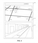
The company explains in the patent that the screen estate (typically a mobile device display) can be divided into different panels to display the Google Maps guidance and the Street View images.
Some navigation applications already use this approach for lane guidance. When you approach an intersection, they divide their UI into two parts, one displaying the suggested route and another showing the available lanes and highlighting the one you must use.
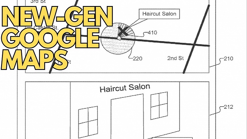
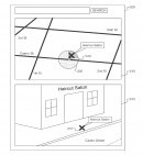
Google wants to do the same thing with Street View imagery. The company proposes a similar concept that will display the suggested route at the top of the screen and Street View photos in the lower part. The split-screen interface would allow users to get a clearer look at the route, understand the next turn, and figure out which way they must go easily.
The approach can be used during navigation and when arriving at a destination. For example, if you go to a store, Google Maps will show you where the destination is located on the map, but with Street View using half of the screen, the application can also display an actual image of the store. The same concept can be used for any destination if Street View already has the requested information.
Additionally, Google Maps can use this approach during navigation to make complex intersections and turns more convenient. Street View can display a preview of the route you must follow on top of Google Maps, so you can compare the images on your mobile device with what you see with your eyes to determine which way you must go.
The idea makes sense, considering how accurate Street View has become, and it can help improve navigation in a way that no other application can currently offer. Apple is probably the only company that can follow in Google's footsteps in this direction, as it already offers a Street View alternative. Look Around is only available in a limited number of regions, as it's included in the detailed city experience rollout that kicked off a few years ago.
Google's idea is currently in the patent stage, so it could take a while until the feature makes its way to the production channel. Companies sometimes file patents only to protect their ideas, but I'm certain the search giant is already exploring ways to integrate Street View into Google Maps more efficiently, especially considering how valuable the street-level imagery can become for drivers (if presented in a convenient manner).
Meanwhile, Google is working around the clock to keep Google Maps at the top of the innovation push in the navigation space. Features like Immersive View are living proof that Google Maps is a continuously evolving platform, but the search giant doesn't want to stop here.
The company has recently patented a new technology that relies on one of its most important assets: Street View.
Called "integrating maps and street views," Google proposes a very simple approach that would significantly improve the navigation experience. Let's dissect this patent and see how it could propel Google Maps to the top of the navigation battle.
Street View in Google Maps
Google captures the photos using cars and even backpacks equipped with advanced hardware, trying to make sure it offers Street View support not only on public roads but also on alleys and in parks where vehicles wouldn't be allowed.
Street View is a fantastic way to get familiar with a region, and the feature is already integrated into Google Maps on all supported platforms, including desktop and mobile.
However, Google already uses the data for more advanced capabilities, including Immersive View for routes. Earlier this month, Google announced this innovative feature that allows users to preview a route using a multi-dimensional world simulation based on imagery provided by Street View and satellites. The service creates a realistic simulation of the route and looks at the weather forecast and historical traffic patterns to let you explore every turn with a spot-on recreation of what you'll likely come across when starting the journey.
Google fuses all this information and brings it under one roof in Immersive View for routes. The company now wants to do the same with Street View imagery integrated even more directly into Google Maps.
The patent
The company explains in the patent that the screen estate (typically a mobile device display) can be divided into different panels to display the Google Maps guidance and the Street View images.
Some navigation applications already use this approach for lane guidance. When you approach an intersection, they divide their UI into two parts, one displaying the suggested route and another showing the available lanes and highlighting the one you must use.
Google wants to do the same thing with Street View imagery. The company proposes a similar concept that will display the suggested route at the top of the screen and Street View photos in the lower part. The split-screen interface would allow users to get a clearer look at the route, understand the next turn, and figure out which way they must go easily.
The approach can be used during navigation and when arriving at a destination. For example, if you go to a store, Google Maps will show you where the destination is located on the map, but with Street View using half of the screen, the application can also display an actual image of the store. The same concept can be used for any destination if Street View already has the requested information.
The idea makes sense, considering how accurate Street View has become, and it can help improve navigation in a way that no other application can currently offer. Apple is probably the only company that can follow in Google's footsteps in this direction, as it already offers a Street View alternative. Look Around is only available in a limited number of regions, as it's included in the detailed city experience rollout that kicked off a few years ago.
Google's idea is currently in the patent stage, so it could take a while until the feature makes its way to the production channel. Companies sometimes file patents only to protect their ideas, but I'm certain the search giant is already exploring ways to integrate Street View into Google Maps more efficiently, especially considering how valuable the street-level imagery can become for drivers (if presented in a convenient manner).
