Apple Maps has long been considered a waste of time for people searching for navigation software, especially following a series of blunders that directed drivers to the middle of nowhere due to incorrect map data.
The days when Apple Maps offered turn-by-turn guidance to oceans, directly into buildings, or streets with no names are long gone, and the detailed city experience, also known as DCE, is part of a major transformation that's slowly turning the service into a Google Maps killer.
The detailed city experience rollout continues slowly, but the good news is that it is making solid progress worldwide. Apple brings it to more users regularly, and the upcoming iPhone launch event will likely witness another expansion.
Before delving into details, let's take a walk down memory lane.
Few people remember this, but Apple invested billions of dollars in acquisitions to build a better mapping platform. Apple Maps was born in September 2012, but Apple started the shopping spree several years before.
In 2009, the company purchased the online mapping service Placebase. Poly9 and C3 Technologies, two startups focused on creating 3D maps, followed in its footsteps in the next couple of years. HopStop, Embark, WifiSlam, Locationary, and Broadmap were other big names in the mapping world that eventually became Apple assets.
Apple invested big bucks into Apple Maps, but the company still had to rely on third parties for the key part of the service. Multiple companies provided the maps, but TomTom was responsible for most of the data available in Apple Maps. The partnership between Apple and TomTom was solid and fueled Apple Maps' ascension for more than half of a decade.
Apple's push for privacy forced the company to embrace a different strategy. The iPhone maker decided to build its own maps, so the debut of the detailed city experience was a natural step.
The detailed city experience was originally available for only four locations: London, Los Angeles, New York City, and the San Francisco Bay Area.
It has since expanded to many other regions, with Apple working as we speak on bringing the same update to more users in the United States and Europe.
Let me start with what I believe is the essential part of the DCE.
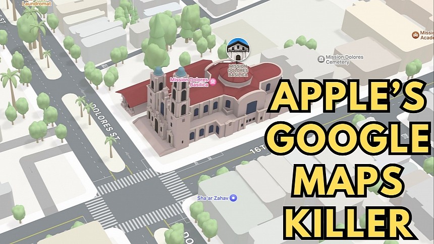
The highly detailed maps include information you won't find in other applications, such as Google Maps. Apple Maps shows trees, sidewalks, medians, crosswalks, building entrances, and many other details that help you conveniently explore a specific location.
The dark mode includes a moonlit glow that automatically activates at dusk.
Users can see elevation details, road labels, stop signs, and traffic lights (these are mainly helpful for drivers), and the most important road details recreated in digital form in Apple Maps.
The custom 3D models created by Apple provide a closer look at stadiums, museums, and other famous landmarks.
The driving experience is enhanced with turn lanes, bus and taxi lanes, and a significantly upgraded lane guidance system that displays a 3D view of the approaching intersection. The rich details help Apple Maps offer more straightforward navigation, so it's easier to figure out which way to go. Apple also displays the location of traffic lights and stop signs during navigation, making the road more predictable.
One of the features that are yet to gain traction is the incident reporting. Apple tried to copy Waze and allow users to report incidents on the road, but the feature feels half-baked and, therefore, records weak adoption. Apple Maps users can only report speed traps, accidents, and other generic hazards. Few people use this feature, including in the United States, where the Apple Maps user base is higher than in other regions.
The DCE also includes Look Around, a feature that competes against Google's Street View with street-level imagery. Look Around offers high-resolution images, so you can walk around a specific location from your mobile device.
And speaking of walking around, DCE comes with immersive walking directions (though this feature is only available in select locations). With this feature, users can get step-by-step walking guidance in augmented reality, so they can scan their surroundings with their smartphone and see which way to go right on the phone's screen.
Apple is expected to announce the next DCE expansion on September 12 during the company's iPhone event. Apple Maps will also receive another important update, with offline maps and features aimed at electric vehicles.
The detailed city experience rollout continues slowly, but the good news is that it is making solid progress worldwide. Apple brings it to more users regularly, and the upcoming iPhone launch event will likely witness another expansion.
Before delving into details, let's take a walk down memory lane.
Few people remember this, but Apple invested billions of dollars in acquisitions to build a better mapping platform. Apple Maps was born in September 2012, but Apple started the shopping spree several years before.
In 2009, the company purchased the online mapping service Placebase. Poly9 and C3 Technologies, two startups focused on creating 3D maps, followed in its footsteps in the next couple of years. HopStop, Embark, WifiSlam, Locationary, and Broadmap were other big names in the mapping world that eventually became Apple assets.
Apple invested big bucks into Apple Maps, but the company still had to rely on third parties for the key part of the service. Multiple companies provided the maps, but TomTom was responsible for most of the data available in Apple Maps. The partnership between Apple and TomTom was solid and fueled Apple Maps' ascension for more than half of a decade.
Apple's push for privacy forced the company to embrace a different strategy. The iPhone maker decided to build its own maps, so the debut of the detailed city experience was a natural step.
The early days of the detailed city experience
The DCE rollout started in September 2021 when Apple announced iOS 15. The company described it as "the biggest update ever" for Apple Maps, promising all kinds of goodies that couldn't be offered without Apple building its own maps.The detailed city experience was originally available for only four locations: London, Los Angeles, New York City, and the San Francisco Bay Area.
It has since expanded to many other regions, with Apple working as we speak on bringing the same update to more users in the United States and Europe.
What’s in DCE?
The detailed city experience doesn't just come down to Apple's new maps. It offers rich details, driving routes with improved navigation, immersive walking directions, speed cameras, Look Around, and incident reporting.Let me start with what I believe is the essential part of the DCE.
The highly detailed maps include information you won't find in other applications, such as Google Maps. Apple Maps shows trees, sidewalks, medians, crosswalks, building entrances, and many other details that help you conveniently explore a specific location.
Users can see elevation details, road labels, stop signs, and traffic lights (these are mainly helpful for drivers), and the most important road details recreated in digital form in Apple Maps.
The custom 3D models created by Apple provide a closer look at stadiums, museums, and other famous landmarks.
The driving experience is enhanced with turn lanes, bus and taxi lanes, and a significantly upgraded lane guidance system that displays a 3D view of the approaching intersection. The rich details help Apple Maps offer more straightforward navigation, so it's easier to figure out which way to go. Apple also displays the location of traffic lights and stop signs during navigation, making the road more predictable.
One of the features that are yet to gain traction is the incident reporting. Apple tried to copy Waze and allow users to report incidents on the road, but the feature feels half-baked and, therefore, records weak adoption. Apple Maps users can only report speed traps, accidents, and other generic hazards. Few people use this feature, including in the United States, where the Apple Maps user base is higher than in other regions.
And speaking of walking around, DCE comes with immersive walking directions (though this feature is only available in select locations). With this feature, users can get step-by-step walking guidance in augmented reality, so they can scan their surroundings with their smartphone and see which way to go right on the phone's screen.
Apple is expected to announce the next DCE expansion on September 12 during the company's iPhone event. Apple Maps will also receive another important update, with offline maps and features aimed at electric vehicles.
