Apple started a massive Apple Maps transformation a few years ago when it announced the detailed city experience. Since then, it's been working around the clock to bring users the new experience worldwide.
The rollout happens gradually and slowly, with Apple enabling the upgraded maps data in new regions every few months.
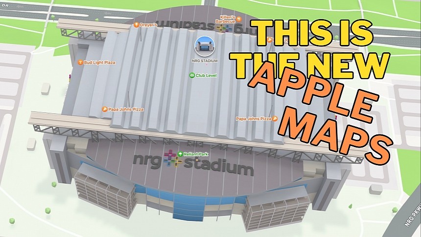
The time has come for the iPhone maker to bring the detailed city experience to Houston and Dallas, as 3D models became available in these regions earlier this week. Apple did not release an announcement for this update, but users can already explore specific landmarks, including the NRG Stadium (as pictured here) in Apple Maps on iPhone and Mac.
Apple's detailed city experience includes rich map details like 3D buildings, crosswalks, sidewalks, trees, and parks.
It also comes with navigation improvements, including street signs and traffic light location, with the information displayed in Apple Maps right on the map. The same data is available on CarPlay when navigation is enabled.
The detailed city experience is Apple's most significant Apple Maps overhaul, as it uses the company's maps. That's also why the global rollout takes so long, as the iPhone maker must collect and process the data before making it widely available.
Apple's efforts to upgrade Apple Maps don't only come down to building a better Google Maps rival but also to creating the necessary map data for more advanced integrations.
The iPhone maker is working on a self-driving vehicle that could launch by the decade's end. Sources familiar with the matter claim the first model should see daylight in 2025 or 2026, though it might sport a more conventional approach with a steering wheel and limited self-driving capabilities. Apple is still aiming for fully autonomous driving, and up-to-date maps are mandatory, so this effort paves the way for a more ambitious project in the long term.
In the meantime, Google Maps is also getting new-generation capabilities, such as the immersive view. The feature combines street-level imagery, satellite data, historical information, and other data to create a realistic view of certain locations, allowing users to explore the world in 3D at specific times of the day and week. The immersive view also enhances navigation, including traffic data and weather conditions, making every journey more predictable by allowing drivers to get familiar with the road before jumping behind the wheel.
Google's immersive view is available only in limited regions today, but the search giant promised to expand it to more locations in the coming months.
The competition in the navigation space becomes fiercer, with a tech giant coalition comprising big names like Microsoft, Meta, Amazon, and TomTom recently rolling out an interoperable map dataset to challenge the domination of Google Maps and Apple Maps.


