Most navigation apps, including Google Maps, Waze, and Apple Maps, can look for driving routes without toll roads, allowing you to reach the destination without paying taxes.
Last year, Google Maps also received an extra feature to provide pricing information to drivers. If you use the application on Android and iPhone, Google Maps can show the toll prices for a suggested route, making it easier to plan a journey.
The feature is not available for all users and comes with a series of shortcomings, but Google promises to address all of them as it works on expanding its availability.
Here's everything you must know about toll pricing in Google Maps.
Disabling and enabling tolls in Google Maps requires just a few taps. Set up a new destination, allow Google Maps to look for a route, and press the three-dot icon in the top right corner. The application should display an entry called "Options." Tap it to see additional trip options.
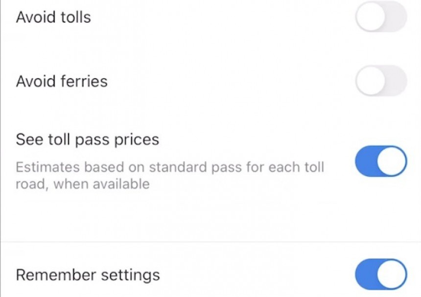
The "avoid tolls" item at the top of the screen allows you to enable and disable tolls in Google Maps. Tap the toggle next to it to enable or disable this feature – if the toggle is activated, Google Maps no longer looks for routes that include toll roads.
The same menu allows you to disable other Google Maps routing options. For example, you can exclude highways from the suggested routes and get turn-by-turn navigation for country roads (where tolls are less likely in the first place).
Additionally, you can configure Google Maps to avoid ferries. The setting instructs Google Maps to look for routes that include driving exclusively, so you won't have to get on a ferry to reach your destination.
Google Maps for Android and iPhone displays toll prices in the United States, India, Japan, and Indonesia, but Google promises to expand the feature's availability to more regions soon. You also can't see toll prices on the desktop, as the data is only live in the mobile version of Google Maps.
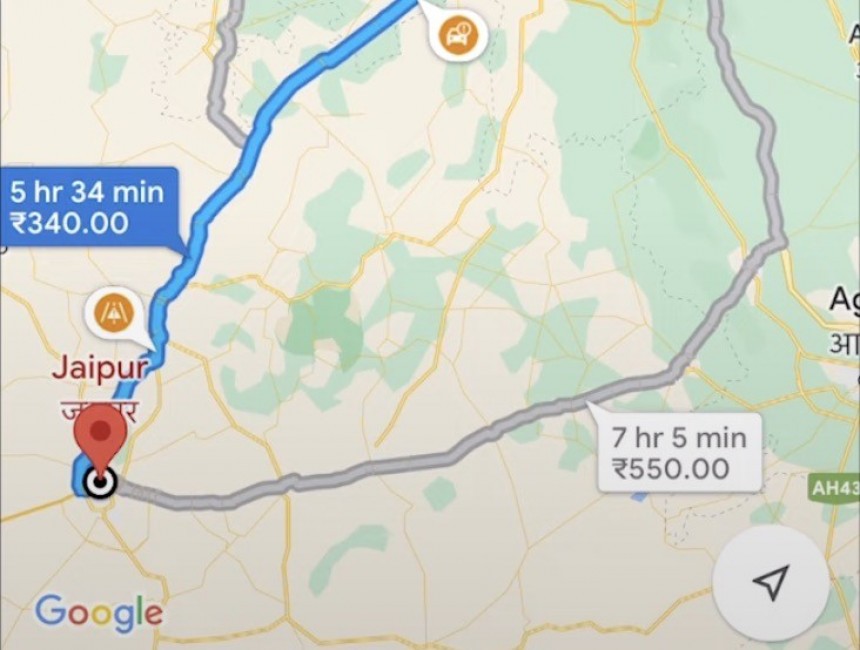
To see toll prices for a selected route, you must first ensure the "avoid tolls" option is disabled. Once you search for a route, click the three-dot menu in the top right corner and launch route options. If the location is supported, Google Maps should display an option called "See toll pass prices." Enable it, and the application should display a toll summary at the top of the screen in the route preview section.
If you wonder how Google Maps calculates toll costs, it all comes down to the official sources the search giant uses to import the data. In other words, Google Maps only uses toll pricing from official sources like government and traffic agencies.
Based on the suggested route and the number of toll passes, Google Maps can eventually calculate how much you'd have to pay to reach a destination by adding all fees.
The search giant tried to make the information as relevant as possible, so Google Maps considers the estimated time you're expected to cross, the day of the week, and other factors that could impact the trip's final cost.
Keeping toll pricing information accurate is a major challenge, even for a tech giant the size of Google. As a result, if you're trying to find out how much the toll is on George Washington Bridge, Google is still your best friend, as relying on Google Maps for such information requires setting up a route that goes through this location.
Apple Maps also displays toll information, but the application does not include pricing data. Its suggested routes can include or exclude toll roads, like in Google Maps, but the Cupertino iPhone maker hasn't yet added pricing details in its navigation software.
You must first configure a destination to avoid toll roads in Apple Maps. When the application finds a route, it displays several settings, including the means of transportation and a drop-down menu called "Avoid." The application allows you to avoid tolls and highways for the configured destination, so tap the toggle to enable this feature.
Apple Maps activates the changes on the spot, looking for a new route that aligns with your configuration. The feature is only available on iPhones, as Apple exclusively offers Apple Maps on its smartphones. Apple Maps does not support Android devices, with the iPhone maker not planning to release the app on Google's mobile operating system.
The feature is not available for all users and comes with a series of shortcomings, but Google promises to address all of them as it works on expanding its availability.
Here's everything you must know about toll pricing in Google Maps.
How to turn tolls on and off in Google Maps on iPhone and Android
Toll roads are enabled by default in Google Maps, but you can request the routing engine to look for a way to reach your destination without taxes.Disabling and enabling tolls in Google Maps requires just a few taps. Set up a new destination, allow Google Maps to look for a route, and press the three-dot icon in the top right corner. The application should display an entry called "Options." Tap it to see additional trip options.
The "avoid tolls" item at the top of the screen allows you to enable and disable tolls in Google Maps. Tap the toggle next to it to enable or disable this feature – if the toggle is activated, Google Maps no longer looks for routes that include toll roads.
Additionally, you can configure Google Maps to avoid ferries. The setting instructs Google Maps to look for routes that include driving exclusively, so you won't have to get on a ferry to reach your destination.
How to see toll prices in Google Maps
Google introduced toll pricing information in Google Maps last year, but the feature is available only in selected regions and for certain roads (Google says that covering the complete road network takes time, so expect news in this regard shortly).Google Maps for Android and iPhone displays toll prices in the United States, India, Japan, and Indonesia, but Google promises to expand the feature's availability to more regions soon. You also can't see toll prices on the desktop, as the data is only live in the mobile version of Google Maps.
To see toll prices for a selected route, you must first ensure the "avoid tolls" option is disabled. Once you search for a route, click the three-dot menu in the top right corner and launch route options. If the location is supported, Google Maps should display an option called "See toll pass prices." Enable it, and the application should display a toll summary at the top of the screen in the route preview section.
If you wonder how Google Maps calculates toll costs, it all comes down to the official sources the search giant uses to import the data. In other words, Google Maps only uses toll pricing from official sources like government and traffic agencies.
Based on the suggested route and the number of toll passes, Google Maps can eventually calculate how much you'd have to pay to reach a destination by adding all fees.
Keeping toll pricing information accurate is a major challenge, even for a tech giant the size of Google. As a result, if you're trying to find out how much the toll is on George Washington Bridge, Google is still your best friend, as relying on Google Maps for such information requires setting up a route that goes through this location.
Apple Maps also displays toll information, but the application does not include pricing data. Its suggested routes can include or exclude toll roads, like in Google Maps, but the Cupertino iPhone maker hasn't yet added pricing details in its navigation software.
You must first configure a destination to avoid toll roads in Apple Maps. When the application finds a route, it displays several settings, including the means of transportation and a drop-down menu called "Avoid." The application allows you to avoid tolls and highways for the configured destination, so tap the toggle to enable this feature.
Apple Maps activates the changes on the spot, looking for a new route that aligns with your configuration. The feature is only available on iPhones, as Apple exclusively offers Apple Maps on its smartphones. Apple Maps does not support Android devices, with the iPhone maker not planning to release the app on Google's mobile operating system.


