They say Google Maps has lost its navigation focus, as the search giant's strategy of turning it into an all-in-one mapping service pushed the service to a different approach.
Google Maps seemed to focus on world exploration more than on anything else, leaving other applications, including Waze, to be in charge of taking users from where they are to where they want to go.
It doesn't mean Google Maps abandoned its navigation component. The application still offered state-of-the-art navigation capabilities, serving as the preferred app for millions of people who needed guidance and traffic information for daily commutes or long trips.
Google Maps has recently refreshed its navigation focus with a feature that completely changes how you preview a route.
Many people don't do this, but the route preview section in every navigation app has a key role in every minute you spend behind the wheel. It allows drivers to get familiar with the route they plan to use, so eventually, the feature makes every journey more predictable.
Google Maps has been offering a route preview option for quite some time, but the Immersive View for routes pushes things to a new level.
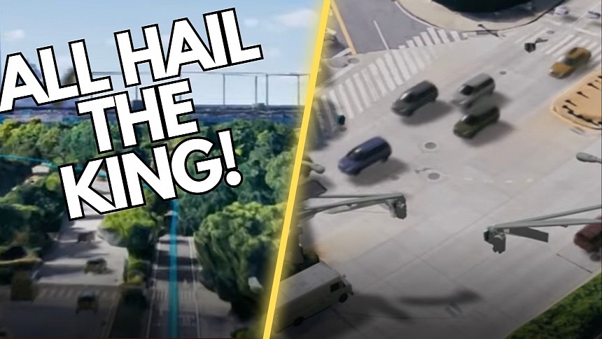
The new feature is based on Immersive View for places, an innovation that Google announced not long ago and whose purpose is to let users explore a certain place using a multi-dimensional view. The system fuses aerial photos with Street View images and Google's 3D models to create a realistic simulation to explore a specific place from a mobile device or a computer.
Immersive View for routes does the same thing for navigation routes. Users can explore their routes in advance, using the same multi-dimensional view combined with traffic patterns, weather conditions, and other helpful information.
Google explains that Immersive View for routes uses imagery from multiple sources, including even planes. Street View cars and trekkers contribute with additional data, so eventually, it combines all images to build the multi-view simulation that must match the information available in the 2D view in Google Maps. The company claims that aligning the data with what's available in Google Maps for correct road and business name information is critical and takes more effort than it seems at first.
Artificial intelligence comes to the rescue specifically to "read" a photo. The system tries to understand what you can see in the collected images so it can recognize sidewalks, speed limits, road names, traffic lights, and everything else. As a result, when you preview a route in Immersive View, you are always provided with correct road information.
Google says that creating a 3D simulation is a highly complex process, and this is why the data you see on Google Maps is captured with special 3D cameras "much like the ones used to film Hollywood movies." It's one of the reasons the Immersive View isn't yet available for all regions worldwide, as Google needs more time to capture 3D images and then create 3D models for every sector of the world.
The 3D view helps, but Google wants the Immersive View to offer a multi-dimensional simulation that allows the user to explore a region and a route from any angle they wish. As a result, the company uses occlusion and B-spline curves to make the preview as realistic as possible.
Eventually, Google Maps plays an essential role in the new route preview system, as the platform contributes with essential information about weather, air quality, and traffic. Google Research provides driving trends, so eventually, Immersive View for routes combines all of the above for a very realistic preview of a route.
Users can explore every section of the road and obtain a digital simulation available on their mobile device while also accessing data like traffic conditions at a specific hour, the expected weather conditions, and even the estimated air quality when they plan to begin the journey.
Immersive View for routes is living proof Google hasn't abandoned the navigation battle, though it involves an amount of work that means it can't bring it to the entire world overnight. It's the reason the company sticks with baby steps for now, so Immersive View for routes is slowly rollout to users worldwide. For now, only users in Amsterdam, Barcelona, Dublin, Florence, Las Vegas, London, Los Angeles, Miami, New York, Paris, San Francisco, San Jose, Seattle, Tokyo, and Venice, but it shouldn't take too long before it becomes available for more people.
Meanwhile, it's hard to believe Immersive View for routes would be copied by other navigation companies, as the tremendous amount of data, the analysis, and the processing involved makes the feature a major challenge for a third party that doesn't have Google's resources. Whether this feature would convince more people to stick with Google Maps is something we'll have to see, but for now, the feature serves as living proof that despite all the criticism, Google Maps is still the top navigation app in the world.
It doesn't mean Google Maps abandoned its navigation component. The application still offered state-of-the-art navigation capabilities, serving as the preferred app for millions of people who needed guidance and traffic information for daily commutes or long trips.
Google Maps has recently refreshed its navigation focus with a feature that completely changes how you preview a route.
Many people don't do this, but the route preview section in every navigation app has a key role in every minute you spend behind the wheel. It allows drivers to get familiar with the route they plan to use, so eventually, the feature makes every journey more predictable.
The new feature is based on Immersive View for places, an innovation that Google announced not long ago and whose purpose is to let users explore a certain place using a multi-dimensional view. The system fuses aerial photos with Street View images and Google's 3D models to create a realistic simulation to explore a specific place from a mobile device or a computer.
Immersive View for routes does the same thing for navigation routes. Users can explore their routes in advance, using the same multi-dimensional view combined with traffic patterns, weather conditions, and other helpful information.
Google explains that Immersive View for routes uses imagery from multiple sources, including even planes. Street View cars and trekkers contribute with additional data, so eventually, it combines all images to build the multi-view simulation that must match the information available in the 2D view in Google Maps. The company claims that aligning the data with what's available in Google Maps for correct road and business name information is critical and takes more effort than it seems at first.
Google says that creating a 3D simulation is a highly complex process, and this is why the data you see on Google Maps is captured with special 3D cameras "much like the ones used to film Hollywood movies." It's one of the reasons the Immersive View isn't yet available for all regions worldwide, as Google needs more time to capture 3D images and then create 3D models for every sector of the world.
The 3D view helps, but Google wants the Immersive View to offer a multi-dimensional simulation that allows the user to explore a region and a route from any angle they wish. As a result, the company uses occlusion and B-spline curves to make the preview as realistic as possible.
Eventually, Google Maps plays an essential role in the new route preview system, as the platform contributes with essential information about weather, air quality, and traffic. Google Research provides driving trends, so eventually, Immersive View for routes combines all of the above for a very realistic preview of a route.
Immersive View for routes is living proof Google hasn't abandoned the navigation battle, though it involves an amount of work that means it can't bring it to the entire world overnight. It's the reason the company sticks with baby steps for now, so Immersive View for routes is slowly rollout to users worldwide. For now, only users in Amsterdam, Barcelona, Dublin, Florence, Las Vegas, London, Los Angeles, Miami, New York, Paris, San Francisco, San Jose, Seattle, Tokyo, and Venice, but it shouldn't take too long before it becomes available for more people.
Meanwhile, it's hard to believe Immersive View for routes would be copied by other navigation companies, as the tremendous amount of data, the analysis, and the processing involved makes the feature a major challenge for a third party that doesn't have Google's resources. Whether this feature would convince more people to stick with Google Maps is something we'll have to see, but for now, the feature serves as living proof that despite all the criticism, Google Maps is still the top navigation app in the world.


