Apple Maps is often considered a top alternative to Google Maps, but users considering the switch end up discovering shortcomings and missing features. Eventually, the migration from Google Maps to Apple Maps is slowed down or even abandoned entirely.
Google Maps and Apple Maps are fighting almost for the same users. The biggest difference comes down to platform availability, as Apple is still keeping Apple Maps exclusive to its operating systems.
Google Maps is available on both iPhone and Android, and thanks to its web version, it can be accessed on macOS as well. Apple Maps, on the other hand, comes pre-loaded on iOS and macOS and does not sport a web-based service accessible from a browser.
In terms of features, the two have copied each other’s ideas, sometimes with a personal twist that improved the final experience. But despite Apple’s efforts to improve Apple Maps, Google Maps continues to be the king of navigation.
This is one awkward approach, as satellite maps are already available in Apple Maps. If you launch the application to explore a specific place, Apple Maps does offer satellite imagery, in some cases with a better resolution than Google Maps. The moment you enable navigation, the satellite images are disabled. Apple Maps returns to the standard map mode.
The satellite mode in Google Maps makes navigation and finding a certain destination significantly more convenient. It’s easier to figure out where you are, especially because satellite images boast impressive quality and resolution.
As if the lack of satellite navigation wasn’t enough, Apple is also ignoring other essential navigation features. For example, Apple Maps does not come with offline maps. As such, users must always have an Internet connection to run the app. Otherwise, Apple Maps wouldn’t be about to provide route guidance.
While a permanent data connection on the smartphone is a must-have anyway, offline maps come in handy in remote areas or regions with a spotty cellular signal. When you drive across such a region, Apple Maps loses the GPS connection and can no longer update the navigation information. If you make a wrong turn, Apple Maps won’t be able to look for a new route.
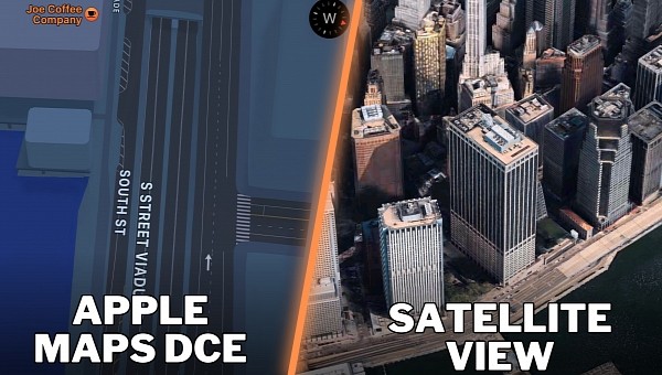
The new Apple Maps started rolling out in waves to users across the world. The detailed city experience that was introduced in 2021 was supposed to provide the platform with a facelift in urban areas, adding incredible details, like vegetation, turn lanes, sidewalks, crosswalks, accurate road widths, and 3D models and buildings.
The detailed city experience was a major update that many believed would eventually turn Apple Maps into a Google Maps killer. Apple, however, never seemed to be in a rush to reach the broad availability phase for this update, so two years later, it’s still rolling out slowly to users out there. The refresh continues to be available only in certain countries, and Apple is still tight-lipped on its expansion plans.
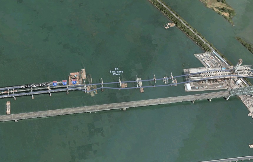
Such a discovery was recently shared on reddit, as someone noticed that the Champlain Bridge, whose construction was finished in 2019, is still in the works on Apple Maps.
The satellite imagery available on Apple Maps is therefore terribly outdated, as the service still hasn’t updated the aerial views nearly four years after the construction was finished.
On the other hand, Apple Maps does accurately render the standard map view of the region and provides navigation guidance in the area.
All these shortcomings certainly limit Apple Maps’ opportunity to grow bigger in a market dominated by Google Maps. The Cupertino-based iPhone maker is working around the clock on improving Apple Maps on several fronts, but so far, it has more or less managed to offer only half-backed updates.
The incident reporting capabilities in Apple Maps are more of a hit-and-miss right now. Somehow pushing Apple Maps closer to Waze in terms of navigation features, the incident reporting only allows users to send three types of reports for accidents, speed traps, and other hazards. The availability is also extremely limited, so coming across a report is rather uncommon.
Given Apple Maps is offered as the native mapping platform on the world’s top smartphone, the parent company is clearly missing a major opportunity here. This could change in the long term, especially as Apple is focusing more on services, but for now, Apple Maps still can’t be considered a Google Maps alternative.
Google Maps is available on both iPhone and Android, and thanks to its web version, it can be accessed on macOS as well. Apple Maps, on the other hand, comes pre-loaded on iOS and macOS and does not sport a web-based service accessible from a browser.
In terms of features, the two have copied each other’s ideas, sometimes with a personal twist that improved the final experience. But despite Apple’s efforts to improve Apple Maps, Google Maps continues to be the king of navigation.
The missing features in Apple Maps
It all starts with the missing features. For some reason, Apple is ignoring essential features for a mapping platform, including the support for satellite navigation.This is one awkward approach, as satellite maps are already available in Apple Maps. If you launch the application to explore a specific place, Apple Maps does offer satellite imagery, in some cases with a better resolution than Google Maps. The moment you enable navigation, the satellite images are disabled. Apple Maps returns to the standard map mode.
The satellite mode in Google Maps makes navigation and finding a certain destination significantly more convenient. It’s easier to figure out where you are, especially because satellite images boast impressive quality and resolution.
As if the lack of satellite navigation wasn’t enough, Apple is also ignoring other essential navigation features. For example, Apple Maps does not come with offline maps. As such, users must always have an Internet connection to run the app. Otherwise, Apple Maps wouldn’t be about to provide route guidance.
While a permanent data connection on the smartphone is a must-have anyway, offline maps come in handy in remote areas or regions with a spotty cellular signal. When you drive across such a region, Apple Maps loses the GPS connection and can no longer update the navigation information. If you make a wrong turn, Apple Maps won’t be able to look for a new route.
The slow rollout of the detailed city experience
Apple kicked off a major Apple Maps transformation back in 2018 when the company started revamping the service with its own map data. The Cupertino-based tech giant, therefore, decided to give up on third parties and build its own map that would help develop a more advanced service.The detailed city experience was a major update that many believed would eventually turn Apple Maps into a Google Maps killer. Apple, however, never seemed to be in a rush to reach the broad availability phase for this update, so two years later, it’s still rolling out slowly to users out there. The refresh continues to be available only in certain countries, and Apple is still tight-lipped on its expansion plans.
The outdated data
It’s not a secret that some of the data available on Apple Maps is outdated, but every now and then, it’s reaching an embarrassing level.Such a discovery was recently shared on reddit, as someone noticed that the Champlain Bridge, whose construction was finished in 2019, is still in the works on Apple Maps.
The satellite imagery available on Apple Maps is therefore terribly outdated, as the service still hasn’t updated the aerial views nearly four years after the construction was finished.
On the other hand, Apple Maps does accurately render the standard map view of the region and provides navigation guidance in the area.
The incident reporting capabilities in Apple Maps are more of a hit-and-miss right now. Somehow pushing Apple Maps closer to Waze in terms of navigation features, the incident reporting only allows users to send three types of reports for accidents, speed traps, and other hazards. The availability is also extremely limited, so coming across a report is rather uncommon.
Given Apple Maps is offered as the native mapping platform on the world’s top smartphone, the parent company is clearly missing a major opportunity here. This could change in the long term, especially as Apple is focusing more on services, but for now, Apple Maps still can’t be considered a Google Maps alternative.


