Google is working around the clock on improving Google Maps, and the latest announcements serve as confirmation the company wants to remain a leader in the navigation space.
Google Maps will get new-generation features, such as Immersive View for routes, allowing users to preview their routes in a realistic simulation of the world in a multidimensional view. The feature uses satellite imagery, street-level photos, traffic conditions, and the weather forecast to predict how a specific location could look.
Google's efforts make sense. The competition in the navigation world is getting fiercer, and Apple's increased focus on Apple Maps proves more companies are now interested in upgraded capabilities for their software.
However, Google wants to continue dominating the navigation battle, so it wants to expand Google Maps on multiple fronts. One of the most recent inventions concerns integrating ride-hailing services in Google Maps, with Google explaining how Street View could make the experience more straightforward and convenient.
The patent describes a technology whose role is to "provide street-level imagery related to a ride service in a navigation application."
Google begins by explaining that the integration of ride-sharing services in Google Maps could be more advanced thanks to the service APIs that allow the navigation app to access information in the likes of Uber. Once Google Maps can invoke the ride service API and access the necessary content, it can provide the user with more useful information powered by its features.
The best example is Street View.
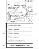
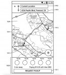
Whenever you order a new Uber, you must define a pickup point by selecting it on the map. The feature is typically very straightforward because the application determines your location, so you can pick a point in proximity with a single tap.
However, the process could be more complicated if you order an Uber in an unfamiliar neighborhood and the pickup location can't be close to your current location. For example, if you're a tourist visiting a town and you are in a shopping center, choosing a pickup location could be more difficult because you're not familiar with the place. You can indeed define a point on the map and walk towards the location using step-by-step instructions, but you still can't be sure you're in the right place until your Uber arrives.
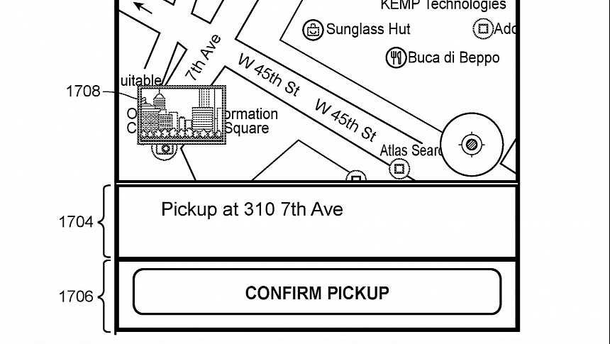
Google wants to address this shortcoming with deeper ride-sharing service integration in Google Maps and access to Street View imagery. When users define a pickup point, they can see the surroundings using Street View photos, so when they walk to the location, they can recognize the area and be sure they're in the right place.
The feature can work in both directions and provide the drivers with street-level imagery powered by Street View to help them find the pickup location.
Google Maps can push the concept further by providing the user step-by-step directions to the selected pickup point. Other features in Google Maps, including the augmented reality view in Street View, could help users find the pickup point more easily.
Lens in Google Maps allows users to scan their surroundings using the mobile phone's camera to get more information on what's around them, including the names of restaurants, their Google ratings, opening hours, and other details. Such features could help users arrive at the pickup point and wait for their Uber in the right location, as long as Google Maps gets deeper integration of ride-hailing services.
Google Maps keeps evolving with advanced capabilities, with the search giant seemingly focusing on multiple fronts simultaneously. Not long ago, the company announced an expansion of its eco-friendly routing engine, providing users with alternatives to the fastest route and helping them cut emissions and reduce fuel consumption. The eco-friendly option debuted in 2021 and is already available in most regions, including Europe and the United States. With this expansion, the parent company brings it to India, adding support for two-wheelers.
The application also gets an improved search feature that lets users find things to do in their neighborhoods more easily. A basic search operation can look for common activities close to the user's location and help them get more information, including opening hours and reviews.
All these capabilities could be further enhanced by adding deeper ride-sharing service integration, connecting the user to more information.
Google's idea is still in the patent stage, but this time, the company might be looking into bringing it to the production phase, considering it could become a money-making machine. Sometimes, companies file patents just to protect their ideas, but Google might be on to something with this Google Maps update. I don't expect the search giant to bring these capabilities to the platform in the coming months, but it'll probably pursue more advanced ties with the likes of Uber in the long term.
You can find the full patent application and the rest of the details in the document embedded below.
Google's efforts make sense. The competition in the navigation world is getting fiercer, and Apple's increased focus on Apple Maps proves more companies are now interested in upgraded capabilities for their software.
However, Google wants to continue dominating the navigation battle, so it wants to expand Google Maps on multiple fronts. One of the most recent inventions concerns integrating ride-hailing services in Google Maps, with Google explaining how Street View could make the experience more straightforward and convenient.
The patent describes a technology whose role is to "provide street-level imagery related to a ride service in a navigation application."
Google begins by explaining that the integration of ride-sharing services in Google Maps could be more advanced thanks to the service APIs that allow the navigation app to access information in the likes of Uber. Once Google Maps can invoke the ride service API and access the necessary content, it can provide the user with more useful information powered by its features.
The best example is Street View.
However, the process could be more complicated if you order an Uber in an unfamiliar neighborhood and the pickup location can't be close to your current location. For example, if you're a tourist visiting a town and you are in a shopping center, choosing a pickup location could be more difficult because you're not familiar with the place. You can indeed define a point on the map and walk towards the location using step-by-step instructions, but you still can't be sure you're in the right place until your Uber arrives.
Google wants to address this shortcoming with deeper ride-sharing service integration in Google Maps and access to Street View imagery. When users define a pickup point, they can see the surroundings using Street View photos, so when they walk to the location, they can recognize the area and be sure they're in the right place.
Google Maps can push the concept further by providing the user step-by-step directions to the selected pickup point. Other features in Google Maps, including the augmented reality view in Street View, could help users find the pickup point more easily.
Lens in Google Maps allows users to scan their surroundings using the mobile phone's camera to get more information on what's around them, including the names of restaurants, their Google ratings, opening hours, and other details. Such features could help users arrive at the pickup point and wait for their Uber in the right location, as long as Google Maps gets deeper integration of ride-hailing services.
Google Maps keeps evolving with advanced capabilities, with the search giant seemingly focusing on multiple fronts simultaneously. Not long ago, the company announced an expansion of its eco-friendly routing engine, providing users with alternatives to the fastest route and helping them cut emissions and reduce fuel consumption. The eco-friendly option debuted in 2021 and is already available in most regions, including Europe and the United States. With this expansion, the parent company brings it to India, adding support for two-wheelers.
The application also gets an improved search feature that lets users find things to do in their neighborhoods more easily. A basic search operation can look for common activities close to the user's location and help them get more information, including opening hours and reviews.
Google's idea is still in the patent stage, but this time, the company might be looking into bringing it to the production phase, considering it could become a money-making machine. Sometimes, companies file patents just to protect their ideas, but Google might be on to something with this Google Maps update. I don't expect the search giant to bring these capabilities to the platform in the coming months, but it'll probably pursue more advanced ties with the likes of Uber in the long term.
You can find the full patent application and the rest of the details in the document embedded below.
