The demise of the Apple Car has made the Cupertino-based tech giant significantly more committed to improving the experience with Apple Maps.
The reason is simple: without an Apple Car, the only way the iPhone maker can expand in the automotive business is with software and services.
Naturally, Apple Maps and CarPlay spearhead this push, with both products projected to receive major updates this year.
However, Apple is also planning in the long term, and a recent patent provides us with an early look at how Apple Maps could offer automatic navigation based on the mode of transportation.
The patent is called "transportation mode specifics navigation user interfaces" and describes how Apple Maps could communicate with the phone's sensors to determine how you navigate.
Apple Maps already offers directions for driving, transit, walking, and cycling, but the user must manually select the mode before beginning navigation. With Apple's new technology, Apple Maps would be able to automatically determine how the user navigates to the destination, adjusting the UI and optimizing the route accordingly.
The patent comprises two related components.
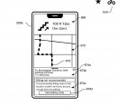
First, Apple explains that the technology allows Apple Maps to determine how you travel using data received from the phone's sensors and display a prompt on the screen.
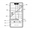
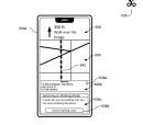
For example, if you walk to a destination but previously selected driving mode, Apple Maps could display a prompt to tell you that it detected you travel on foot. The message allows the user to ignore the prompt or switch to walking directions, in which case Apple Maps reconfigures the route to look for walking-optimized directions. The new route could be different from the previous suggestion, as it might include alleys and other roads where a vehicle wouldn't fit or be allowed.
The same approach works for the other travel modes. Apple Maps would be able to recognize walking, driving, cycling, and public transportation, offering automatic prompts and suggesting new routes. Users would always be in full control of the route, so if Apple Maps doesn't correctly determine your mode of transportation, they can ignore the prompt and continue navigation in the selected mode.
The second component involves navigation to a destination using multiple transportation modes with or without automatic detection.
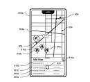
A route to a destination could include more than a single transportation mode. For example, if you want to go to a store that you can't reach by car but still want to drive as close to the destination as possible, you can use Apple Maps with a multi-mode route. The application would attempt to find a driving route to a location near the destination and offer walking directions for the rest of the route.
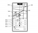
Users can define each mode in the route configuration screen, defining how they want to travel for each section. They can use all travel modes, including driving, cycling, walking, and public transportation, and combine them as you want to allow Apple Maps to offer step-by-step guidance to the destination.
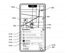
In one scenario, the patent explains that Apple Maps would be able to determine the transportation mode based on the approach above and adjust guidance accordingly. For example, users would only have to configure a destination and start navigation, letting Apple Maps determine how they travel. When they park the car and start walking, Apple Maps should determine a travel mode change and switch to walking directions. When cycling, the application does the same thing and looks for cycling routes.
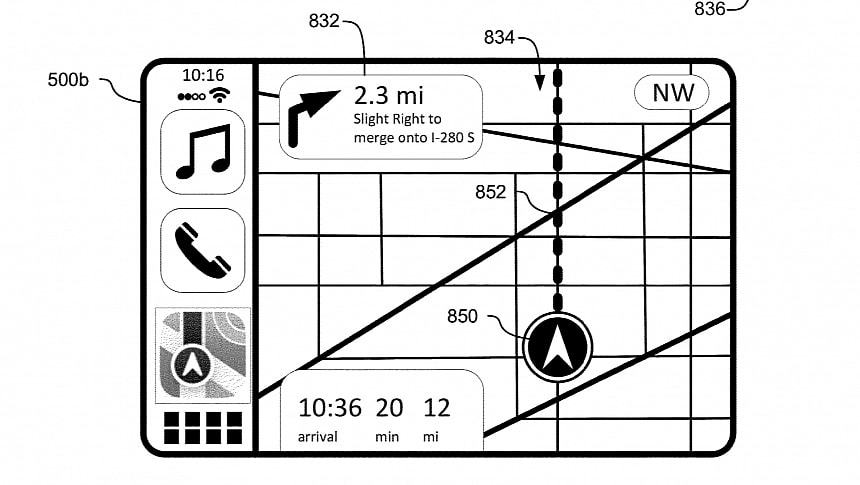
Apple explains that Apple Maps would adjust its interface based on the display mode. For example, the application can display similar information when running on CarPlay – a connection to the vehicle could also be a sign that the driving mode is enabled, with Apple Maps switching to car-optimized routes automatically.
Apple's idea is to make Apple Maps work as seamlessly as possible and turn the application into the right navigation component regardless of the travel mode. The application would require as little user interaction as possible, allowing users to get the automatic detection or rely on manual configuration for every route. Users will still be allowed to choose how to use the app, as manual switching will be permitted at any point during navigation.
The technology is still in the patent stage, and it's important to understand that Apple might not pursue the idea and bring it to the production stage. Companies worldwide typically file patents to protect their ideas but aren't always interested in beginning mass production. However, considering Apple has become very committed to improving Apple Maps in the short and the long term, I wouldn't be surprised to see the company bringing more revolutionary features to the application.
You can find the entire patent document in the box after the jump if you're interested in the technical details and let me know if this feature would convince you to abandon Google Maps and switch to Apple's navigation app.
Naturally, Apple Maps and CarPlay spearhead this push, with both products projected to receive major updates this year.
However, Apple is also planning in the long term, and a recent patent provides us with an early look at how Apple Maps could offer automatic navigation based on the mode of transportation.
The patent is called "transportation mode specifics navigation user interfaces" and describes how Apple Maps could communicate with the phone's sensors to determine how you navigate.
Apple Maps already offers directions for driving, transit, walking, and cycling, but the user must manually select the mode before beginning navigation. With Apple's new technology, Apple Maps would be able to automatically determine how the user navigates to the destination, adjusting the UI and optimizing the route accordingly.
The patent comprises two related components.
For example, if you walk to a destination but previously selected driving mode, Apple Maps could display a prompt to tell you that it detected you travel on foot. The message allows the user to ignore the prompt or switch to walking directions, in which case Apple Maps reconfigures the route to look for walking-optimized directions. The new route could be different from the previous suggestion, as it might include alleys and other roads where a vehicle wouldn't fit or be allowed.
The same approach works for the other travel modes. Apple Maps would be able to recognize walking, driving, cycling, and public transportation, offering automatic prompts and suggesting new routes. Users would always be in full control of the route, so if Apple Maps doesn't correctly determine your mode of transportation, they can ignore the prompt and continue navigation in the selected mode.
The second component involves navigation to a destination using multiple transportation modes with or without automatic detection.
Users can define each mode in the route configuration screen, defining how they want to travel for each section. They can use all travel modes, including driving, cycling, walking, and public transportation, and combine them as you want to allow Apple Maps to offer step-by-step guidance to the destination.
In one scenario, the patent explains that Apple Maps would be able to determine the transportation mode based on the approach above and adjust guidance accordingly. For example, users would only have to configure a destination and start navigation, letting Apple Maps determine how they travel. When they park the car and start walking, Apple Maps should determine a travel mode change and switch to walking directions. When cycling, the application does the same thing and looks for cycling routes.
Apple explains that Apple Maps would adjust its interface based on the display mode. For example, the application can display similar information when running on CarPlay – a connection to the vehicle could also be a sign that the driving mode is enabled, with Apple Maps switching to car-optimized routes automatically.
The technology is still in the patent stage, and it's important to understand that Apple might not pursue the idea and bring it to the production stage. Companies worldwide typically file patents to protect their ideas but aren't always interested in beginning mass production. However, considering Apple has become very committed to improving Apple Maps in the short and the long term, I wouldn't be surprised to see the company bringing more revolutionary features to the application.
You can find the entire patent document in the box after the jump if you're interested in the technical details and let me know if this feature would convince you to abandon Google Maps and switch to Apple's navigation app.
