Google Maps, Waze, and Apple Maps command the mobile automotive space, and a growing number of companies, including navigation experts from TomTom, HERE, and Sygic, are joining the fight.
However, statistics show that Google Maps and Waze are often the top choices in the mobile navigation battle, followed by Apple Maps.
The adoption of Apple's solution is mainly impacted by its limited availability. Compared to Google Maps and Waze, which are available on Android and iOS and also received Android Auto and CarPlay support, Apple Maps is exclusive to Apple users.
It's pre-loaded with the iPhone and runs on CarPlay, with no Android and Android Auto version currently available. Apple has no plans to expand Apple Maps beyond the iOS world.
Each of these apps comes with a signature feature that sets it apart from the rest of the crowd. It's one of the reasons Google keeps Google Maps and Waze on the market simultaneously, despite many users claiming they have become redundant offerings.
The top feature in Waze is undoubtedly its incident reporting engine. Many have tried to copy this idea, including Apple, but Waze's reporting system remains the most advanced on the market, becoming the main feature people give up on Google Maps.
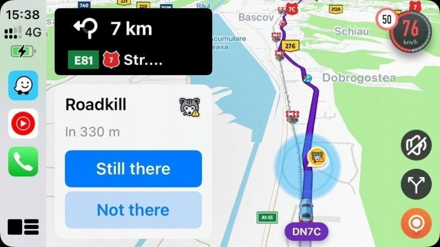
The incident reporting system allows users to send traffic reports about the hazards they find on the road. It includes a wide range of hazards, starting with the most common – accidents, traffic jams, speed traps, and potholes – and ending with rarer dangers – roadkill, unplowed roads, flood, and fog.
Waze uses the data to generate warnings for other users. When someone marks the location of a hazard on the map using the reporting engine, Waze receives the data and generates a warning forwarded to users whose routes include the flagged location. When motorists approach the location of the hazard, they see a notification on the screen with the type of hazard reported by other users.
The hazard reporting system helps make every trip more predictable, as drivers get extra time to slow down when approaching a flagged location. For example, if you get an accident notification on the screen, the chances of a potential pile-up are high, especially on a highway, so Waze gives you precious extra seconds to reduce the speed.
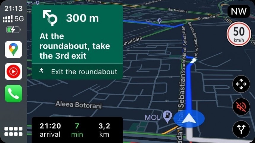
It's hard to name just one thing that sets Google Maps apart from the rest of the navigation herd, but I think the data the application throws at the user is its main selling point.
Google Maps is a data monster, so you can use it to find any address, including businesses, stores, parking spots, and buildings.
The business information, which includes store opening hours and reviews, is an incredibly valuable feature for users who can decide if a certain location is worth visiting before beginning a journey.
Google Maps also shows how crowded a specific place is so drivers can plan navigation accordingly. I use this information regularly, especially for parks, as it allows me to estimate how crowded it'll be when I take my kid out for a quick bike ride. The information is surprisingly accurate and could also help drivers determine how easy it'll be to find a parking spot when they arrive at a destination.
Apple Maps tries to follow in Google Maps' footsteps, but the application progresses slowly, mainly as it's tied to iOS updates and can't receive improvements separately.
iOS 17 introduced offline maps, a long-overdue update, but the biggest new feature is undoubtedly the detailed city experience.
Announced approximately four years ago, the detailed city experience is an amazing pack of improvements that allows Apple Maps to migrate from third-party maps to in-house maps. Apple Maps now uses Apple's maps, offering amazing attention to detail.
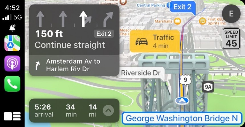
The maps now show medians, crosswalks, sidewalks, 3D buildings, and lanes using accurate details. The navigation component has also been improved with stop signs and traffic light information so you can see their location when approaching an intersection. This data gives users more time to slow down, reducing the likelihood of running a red light or missing a stop sign.
The detailed city experience also includes Waze-like incident reporting, though the feature is still in its early days and lacks more advanced reports. Apple Maps only allows users to report accidents, speed traps, and other generic hazards. However, considering the detailed city experience is still rolling out worldwide, the adoption of incident reporting in Apple Maps is still lackluster.
Apple Maps remaining an Apple-exclusive app also impacts its availability, as the iPhone maker refuses to bring its navigation app to Android devices. Now that the Apple Car project has been ditched, Apple could rethink its strategy and decide to expand Apple Maps, as keeping it locked to its ecosystem could affect its automotive expansion in the long term.
The adoption of Apple's solution is mainly impacted by its limited availability. Compared to Google Maps and Waze, which are available on Android and iOS and also received Android Auto and CarPlay support, Apple Maps is exclusive to Apple users.
It's pre-loaded with the iPhone and runs on CarPlay, with no Android and Android Auto version currently available. Apple has no plans to expand Apple Maps beyond the iOS world.
Each of these apps comes with a signature feature that sets it apart from the rest of the crowd. It's one of the reasons Google keeps Google Maps and Waze on the market simultaneously, despite many users claiming they have become redundant offerings.
Waze
The incident reporting system allows users to send traffic reports about the hazards they find on the road. It includes a wide range of hazards, starting with the most common – accidents, traffic jams, speed traps, and potholes – and ending with rarer dangers – roadkill, unplowed roads, flood, and fog.
Waze uses the data to generate warnings for other users. When someone marks the location of a hazard on the map using the reporting engine, Waze receives the data and generates a warning forwarded to users whose routes include the flagged location. When motorists approach the location of the hazard, they see a notification on the screen with the type of hazard reported by other users.
The hazard reporting system helps make every trip more predictable, as drivers get extra time to slow down when approaching a flagged location. For example, if you get an accident notification on the screen, the chances of a potential pile-up are high, especially on a highway, so Waze gives you precious extra seconds to reduce the speed.
Google Maps
Google Maps is a data monster, so you can use it to find any address, including businesses, stores, parking spots, and buildings.
The business information, which includes store opening hours and reviews, is an incredibly valuable feature for users who can decide if a certain location is worth visiting before beginning a journey.
Google Maps also shows how crowded a specific place is so drivers can plan navigation accordingly. I use this information regularly, especially for parks, as it allows me to estimate how crowded it'll be when I take my kid out for a quick bike ride. The information is surprisingly accurate and could also help drivers determine how easy it'll be to find a parking spot when they arrive at a destination.
Apple Maps
iOS 17 introduced offline maps, a long-overdue update, but the biggest new feature is undoubtedly the detailed city experience.
Announced approximately four years ago, the detailed city experience is an amazing pack of improvements that allows Apple Maps to migrate from third-party maps to in-house maps. Apple Maps now uses Apple's maps, offering amazing attention to detail.
The maps now show medians, crosswalks, sidewalks, 3D buildings, and lanes using accurate details. The navigation component has also been improved with stop signs and traffic light information so you can see their location when approaching an intersection. This data gives users more time to slow down, reducing the likelihood of running a red light or missing a stop sign.
The detailed city experience also includes Waze-like incident reporting, though the feature is still in its early days and lacks more advanced reports. Apple Maps only allows users to report accidents, speed traps, and other generic hazards. However, considering the detailed city experience is still rolling out worldwide, the adoption of incident reporting in Apple Maps is still lackluster.
Apple Maps remaining an Apple-exclusive app also impacts its availability, as the iPhone maker refuses to bring its navigation app to Android devices. Now that the Apple Car project has been ditched, Apple could rethink its strategy and decide to expand Apple Maps, as keeping it locked to its ecosystem could affect its automotive expansion in the long term.


