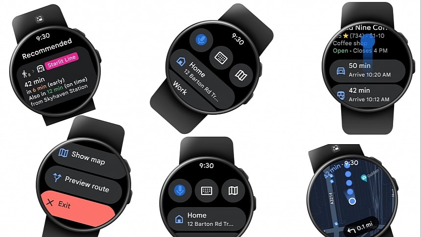
Using Google Maps navigation must be as convenient and straightforward as possible, as users must get their directions with a quick glance at the screen. It's an essential part of the experience with Google Maps, especially now that the application is already available on multiple devices, not just mobile phones.
Google has tried to make Google Maps navigation more convenient everywhere, including in the car, where the company keeps refining the turn-by-turn guidance with every update.
Now, Google is bringing public transit directions on Google Maps to Wear OS smartwatches.
The first time I used navigation on a smartwatch was many years ago when I owned an Apple Watch. If you've never tried this feature, you'll be amazed by how convenient it is to walk to a destination without having to keep your smartphone in hand all the time. All navigation instructions appear on the smartwatch, so you just turn your wrist, look at the watch, and continue walking.
Google Maps on Wear OS makes public transit as convenient as possible, as users can pick routes and get all directions on the AOD screen. The Wear OS integration also lets users preview routes, compare ETAs, and see the map with the highlighted route. The experience is impressive, considering the limited screen estate.
Google is reportedly enabling public transit support in Google Maps for Wear OS with a server-controlled rollout, so make sure you keep your smartphone and apps up-to-date.
Meanwhile, Google Maps keeps evolving on other platforms, too. Google Maps for Android Auto is getting more love, with the application showing the parking location on the screen before drivers turn off the engine. The feature has been around on Android smartphones for years, coming in handy whenever the parking location is different from the destination configured in Google Maps.
The application can continue running on the mobile device for an uninterrupted experience, offering walking directions from the parking location to the configured address. Users can also run Google Maps when they walk back to the car to get step-by-step guidance.
Google Maps is also getting a 3D building layer for navigation on Android Auto, although the latest tests have shown that the feature still needs polishing before mass availability is reached. Theoretically, such an update would allow users to figure out where they are and where they need to go to follow the suggested route more conveniently, but the existing version only makes the interface more cluttered.
Google Maps remains the number one navigation app on Android and iPhone, despite Apple investing big in Apple Maps. The improved features on Wear OS prove the company wants to expand the app on new fronts, and navigation on the wrist is a feature that many users will fall in love with after trying it out for the first time.


