Methane is not only highly toxic, but it’s also hard to detect from space or even at the leak site, with methane clouds being “invisible.” After the dramatic leaks at the Nord Stream 1 and 2 last week, the German Aerospace Center (DLR) and its partners hurried to conduct airborne measurements at the site for the first time and to monitor the infrastructure.
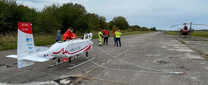
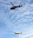
Recently, a helicopter and a helipod hanging from it could be spotted flying above the Nord Stream 1 and 2 natural gas pipelines in the Baltic Sea.
The helicopter came from the Polish company Helipoland, and the helipod, carrying several instruments for atmospheric measurements, is operated by the Institute of Flight Guidance (IFF) of the Technical University of Braunschweig. The two were part of an operation organized by DLR in order to investigate the methane leakage that made headlines all over the world.
Equipped with specific methane measurement instruments in addition to its standard systems, the helipod from hanging from a 25-meter (82 feet) rope as the helicopter flew around the area. The operation started off the Polish coast, near Kohlberg, with the helipod reaching as low as 50 meters (164 feet) above sea level.
The detailed data collected by the instruments were then displayed wirelessly in the helicopter’s cockpit. A total of two flights were carried out, helping measure the upwind and downwind sides of the leak locations. Why were these airborne measurements necessary, when we have satellites, you might ask. Anke Roiger from the DLR Institute of Atmospheric Physics explained that these flights bridged the gap between ground observations and satellite ones.
Even modern satellites apparently can’t accurately measure methane levels in the atmosphere, especially when they’re located over the sea. This is set to change in the near future as DLR and other players develop more efficient laser-based LIDAR sensors. These would help make satellites weather-independent.
It might not seem like a lot, but this scientific mission that was put together in record time helped scientists get a better picture of how much methane continues to leak, as well as its spreading pattern. The biggest goal is to reach a high level of accuracy for critical maritime infrastructure monitoring in the future.


