I will always remember December 26, 2004. Not because it was the second day of Christmas, but because it was then when one of the biggest earthquakes in modern history took place off the west coast of Indonesia. History would go on to record the event as the Sumatra–Andaman earthquake.
Specialized apparatus around the world put the magnitude of the earthquake at over nine on the Richter scale. That's at the upper end of measurable quakes, but the number may not mean all that much to those who haven't directly experienced such a thing.
But the effects of the event paint an incredibly accurate picture of what it means. The thing was so powerful it impacted Earth's rotation and effectively made days shorter. It also changed the planet's shape a bit and, according to NASA data, it shifted the position of the North Pole by several centimeters.
The quake exploded on the intersection of the Burma and Indian tectonic plates. That's underwater, and as we all know, when something like this happens a tsunami almost always follows.
The one of 2004 was unlike anything our generation had ever seen. Named the Boxing Day Tsunami because it occurred on the day after Christmas, it manifested through waves as tall as 30 meters (100 feet), literally obliterating coastal settlements in about a dozen countries, but mostly in Indonesia, Sri Lanka, India, Maldives, and Thailand. In all, about 225,000 people lost their lives.
Ever since December 26, 2004, I always felt my heart shrink whenever another tsunami alert is issued. And there have been plenty of instances of that happening since, with the killer wave that hit Japan in 2011 being one of the most devastating.
Photo: NOAA
Despite the fact most of the time we do get tsunami alerts, the world probably misses on a lot of others that take place unnoticed. That's because at the time of writing humans have only one way of detecting such manifestations of the oceans before they hit shores: the National Oceanic and Atmospheric Administration (NOAA) buoys.
Called DART (short for Deep-ocean Assessment and Reporting of Tsunamis), they are means of detection placed "at strategic locations throughout the ocean." That ocean would be the Pacific, the place where some 750 confirmed tsunamis occurred over the past century.
But the DART buoys have several disadvantages, the biggest being there are not enough of them out there. A reason for that may be the fact they're expensive to make. They work as advertised, but in some cases they miss warning signs entirely, and when they don't they can only provide so much advance warning to coastal communities.
Sadly, excluding the deployment of more DARTs in the ocean there's not much we can do about that. Luckily, NASA's JPL may have a solution for faster and better tsunami warning tech that doesn't even have anything to do with water, but with navigation satellites.
Our planet is presently surrounded by a shroud of such machines. Collectively called Global Navigation Satellite Systems (GNSS), the network comprises the American Global Positioning System (GPS), Europe's Galileo, Russian Glonass, and Chinese BeiDou.
Photo: NOAA
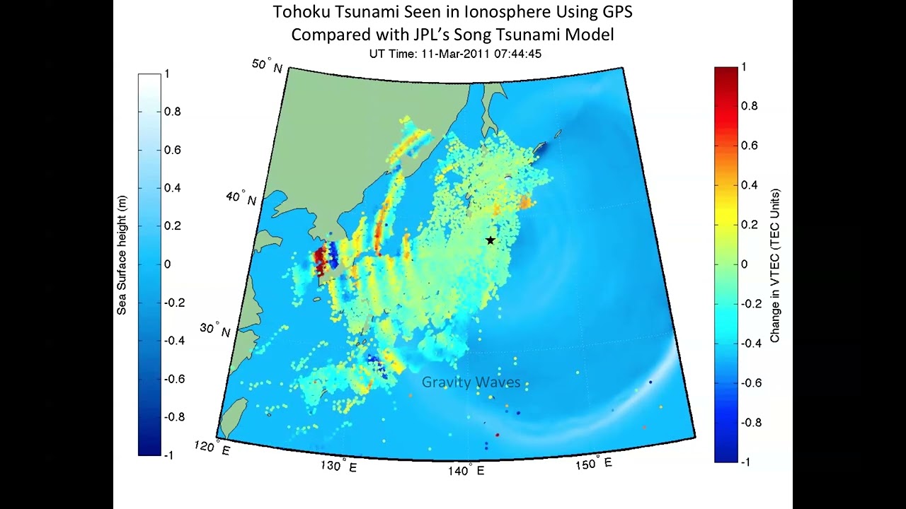
The goal of these satellites is of course facilitate all forms of transportation, but scientists have found they could also be used to detect the formation of a tsunami by simply reading atmospheric disturbances.
When an underwater earthquake takes place (or an undersea eruption), the shock waves generated hit the water above and cause it to swell far above normal levels. This happens over huge distances on the surface of the ocean.
So much water rising significantly at the same time displaces the air above, which is sent rippling in all directions as either low-frequency sound or pressure waves. The mass of displaced air reaches the ionosphere just minutes after they've been generated, causing quite the disturbance up there.
Turns out that GPS satellites, which generally have ways of correcting distortions coming from an unsettled ionosphere, can also be used to detect potential tsunamis. The way this works is that instead of correcting such distortions or branding them as errors, a series of ground stations can be used to collect and analyze them in the search for signs of natural disasters in the making.
NASA names this new approach the GUARDIAN. That stands for GNSS Upper Atmospheric Real-time Disaster Information and Alert Network, and it is already in use as a complementary tool for the NOAA buoys in the Pacific Ocean.
Data from GPS satellites is collected by hundreds of ground stations and then sent to the JPL Global Differential GPS. Ran through this system, the GPS data comes out the other end with a real-time positional accuracy of the potential tsunami down to just 10 centimeters.
The incredible accuracy of this approach is doubled by the fact satellites detect such disturbances within minutes, greatly increasing warning time – to as much as an hour before the waves hit the shores.
There are two major issues with the GUARDIAN, though, and that's the amount of data received and the amount of manpower needed to handle it. At the moment, only trained experts (unclear how many of them there are) can determine which GPS signal is a tsunami and which is just background nouse, so for the moment the tech is limited to looking at just half of the Pacific Ocean's Ring of Fire.
Plans are to make the GUARDIAN system a full-time assistant for the DART buoys, so the people behind the project are working on an open website that could allow experts to "explore the state of the ionosphere in near real-time by studying individual satellite station links on the GNSS network."
The ultimate goal is to have an automated GUARDIAN system capable of identifying tsunamis on its own, without human input, and triggering the necessary alerts. Moreover, the same method could be used to flag incoming disasters caused by volcanic eruptions and land-based earthquakes.
Sadly, no estimate is given as to when such an incredible tech could be fully operational.
Daniel loves writing (or so he claims), and he uses this skill to offer readers a "behind the scenes" look at the automotive industry. He also enjoys talking about space exploration and robots, because in his view the only way forward for humanity is away from this planet, in metal bodies. Full profile
Would you like AUTOEVOLUTION to send you notifications?