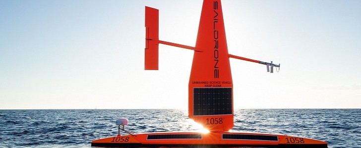
The company whose drones made global headlines last year for capturing the world’s first video from inside a category 4 hurricane stays true to its mission of keeping coastal communities safe. Saildrone recently announced the opening of its new operations center and ocean mapping facility in St. Petersburg, Florida.
The location of the new center was carefully chosen to serve as a permanent deployment site for Saildrone missions. The company plans to use its modern technology and fleet of USVs (uncrewed surface vehicles) for ocean and habitat mapping, as well as for helping scientists understand the causes of hurricane intensification.
At the same time, Saildrone also wants to deploy maritime security missions that can support authorities fight illegal fishing and waterborne drug trafficking, which have devastating effects on the economy.
According to Saildrone CEO Richard Jenkins, new high-resolution maps of the seabed are essential to help Florida protect communities, while also growing its blue economy and facilitating sustainable aquaculture and alternative energy. He also added that USVs are a more cost-effective solution than traditional approaches, being able to accomplish more with far less investment.
Saildrone is a San-Francisco-based USV manufacturer whose ocean drones have now totaled 15,000 days spent at sea (which is over 40 years), covering a total of 500,000 nautical miles (575,000 miles/925,000 km).
There are three models of floating drones in the company’s fleet: Explorer, Surveyor, and Voyager. All of them are powered by a combination of solar and wind energy, allowing them to operate non-stop seven days a week for up to a year, without the need for refueling or maintenance work.
Saildrone’s drones can withstand waves that are over 10 ft (3 m) tall and winds of over 70 mph (112 kph).
Back in October, one of the company’s USVs ventured right into the eye of hurricane Sam, facing 50 ft (15.2 m) waves and winds stronger than 120 mph (193 kph). The drone collected live data from inside the hurricane. This kind of data plays an important role in helping scientists improve forecast models so that coastal communities can better prepare to face future hurricanes.


