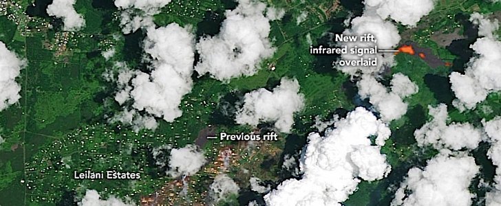
In an attempt to aid the U.S. Geological Survey's disaster response team, NASA spun up its satellites to capture images of the Kilauea volcano eruption.
NASA says it used the Landsat 8 satellite and its Operational Land Imager (OLI) to snap a natural-color image of the eruption. By layering into the image shortwave infrared, the agency was capable of detecting the unusually warm temperatures associated with lava.
NASA says it currently has seven instruments mounted on various satellites providing information about the eruption patterns and atmospheric impacts of the Kilauea eruption.
The data available pertains to the detection of active fissures, fires, ash and sulfur dioxide plumes, deformation of the ground caused by magma movement, and the height and composition of volcanic plumes.
"One of the first things emergency responders wanted to know was where the lava was coming out, where are all the fissures," said J. Carver Struve, NASA emergency management co-lead.
The Hawaii volcanic eruption began in the first days of the month, spewing ash and lava, right on top of a residential area called Leilani Estates.
Since the eruption, two separate lava flows have reached the Pacific, adding laze, a dangerous mix of steam, hydrochloric acid and glass particles, to the already dangerous stew of toxic stuff coming up from under the ground.
"Stay away from any ocean plume. The plume travels with the wind and can change direction without warning," Hawaii's Civil Defense Agency said in a statement.
Luckily, until now the eruption failed to cause any casualties, with thousands being evacuated. The first serious injury was reported last weekend, after a man got hit by a lava projectile while sitting on his balcony.
Travel by car on Hawaii’s Big Island is hindered by lava which reached parts of a coastal road. The wall of molten rock reached on Monday a geothermal power plant which provides about 25 percent of the Big Island’s power.


