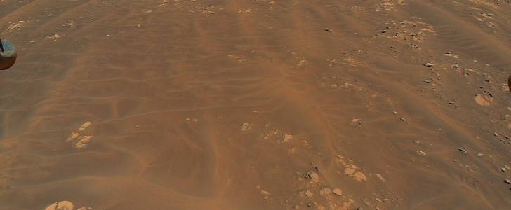
On July 5th, NASA's little helicopter attempted its most challenging journey since its arrival on Mars. What turned out to be a record flight in the thin atmosphere of the Red Planet also gave scientists the opportunity to snap pictures of an unexplored region crossed by very "intriguing" terrain.
Ingenuity's ninth flight was part of its operational demonstration phase, which was aimed to evaluate the helicopter's potential as an aerial scout. For that, the rotorcraft flew faster than ever to the south over a field called Séítah.
Because the area is crossed by sandy ripples and rocky terrain that are difficult to travel for wheeled vehicles like Perseverance rover, only Ingenuity was able to go through it. The rover had to take a detour south around those dunes.
On its way, the helicopter didn't miss the chance to take stunning pictured of the field under. The team of researchers behind Perseverance would never be able to see Séítah in such detail. The aerial perspective allows them to examine the rocks and gain a better knowledge of this area, which is part of the Jezero Crater.
The rover team can see far more details in the color images snapped by Ingenuity, which were shot from a height of roughly 33 ft (10 meters), than they can in the orbiter images they usually use for route planning. While a camera aboard NASA's Mars Reconnaissance Orbiter is able to distinguish rocks up to 3 ft (1 meter) in diameter, most missions rely on rover photos to see smaller rocks or terrain features.
This time, Ingenuity sent back several HD images that almost look too good to be real. One shot features a section of Séítah filled with rocky terrain. Nicknamed by scientists "Raised Ridges," the rocks belong to a fracture system, which often serves as pathways for fluid to flow underground. This section in the crater, which is thought to have once been flooded with water, makes it a suitable location to look for signs of ancient life on Mars.
Igenuity also captured photos of sand dunes, which will help scientists in determining Perseverance's route. As the rover makes its way around the dune area, it may attempt what scientists call a "toe dip" into some spots that contain a bedrock worth studying.
Even if Perseverance wouldn't make a toe dip here, the images sent back by the helicopter will help NASA plan future toe-dip paths in other areas during Perseverance's first science campaign, which will see the rover explore the Jezero Crater's oldest geologic features and collect samples from the crater's floor in search of signs of ancient microbial life.


