Google Maps is an incredible piece of software that can make the experience behind the wheel a lot safer and more convenient. But a family of four from Australia learned the hard way that the navigation offered by Google Maps isn’t always flawless.
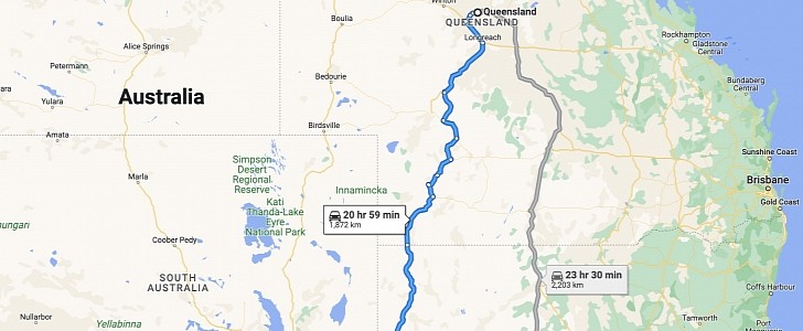
27-year-old Darian Aspinall was traveling with her two- and four-year-old kids and 50-year-old mother from Queensland to Adelaide, with the local media revealing the car left the Noccundra Hotel on Sunday afternoon.
Shortly after that, however, the family of four could no longer be reached, leading to a massive search launched by the local authorities in order to locate the vehicle.
As it turns out, the driver was using Google Maps to get turn-by-turn directions to the destination in Adelaide. The navigation app, however, took the driver off the highway and guided her to a dirt road where the four-wheel-drive SUV ended up struggling.
The vehicle eventually got stuck in the middle of nowhere, where a cellular signal wasn’t available. The family decided to go on foot in order to seek help, but after walking for hours, they decided to return to the vehicle and wait for someone to find them.
48 hours later, a helicopter spotted four people who were waving for help using their clothes, just to make sure the pilot sees them. As it turns out, they had already run out of food and water by the point the helicopter showed up.
The family was eventually rescued and brought to safety, with the police revealing that Google Maps was the one that sent the driver to the dirt road.
Of course, it’s easy to blame Google Maps for suggesting a bad road, but on the other hand, what the application (and all the other navigation solutions out there) tried to do was find a faster route to the destination. It’s entirely up to the driver to decide if a certain route can be used or not, especially because Google Maps itself has no idea what vehicle they’re driving in the first place and whether a road is appropriate or not.
As a general recommendation, if a road suggested by the navigation app looks dangerous, the driver should better stick with the safer route, despite the increased ETA.


